|
SKYWARN Storm Spotting
![[SKYWARN Logo] [SKYWARN Logo]](/resources/Pictures/WX4AKQ_SW_Logo_Only.png) The SKYWARN program is a loosely organized nationwide group of volunteers who are trained to recognize and report severe weather events to the National Weather Service with the goal of saving lives by improving warning accuracy. Since the 1970's, ordinary citizens across the country have given their time and skills to the SKYWARN program, and amateur ("ham") radio has played an important role in the collection of these reports.
The SKYWARN program is a loosely organized nationwide group of volunteers who are trained to recognize and report severe weather events to the National Weather Service with the goal of saving lives by improving warning accuracy. Since the 1970's, ordinary citizens across the country have given their time and skills to the SKYWARN program, and amateur ("ham") radio has played an important role in the collection of these reports.
In some areas, SKYWARN programs are organized by local emergency management teams or community groups. In other areas, ham radio clubs provide all SKYWARN training and services.
Locally, the National Weather Service Forecast Office in Wakefield, Virginia administers the SKYWARN program throughout the Wakefield County Warning Area (CWA) which includes 66 counties and independent cities in central and southeastern Virginia, northeastern North Carolina, and the southern Maryland eastern shore. The Wakefield SKYWARN Amateur Radio Support Team (WX4AKQ) is the ham radio extension of the SKYWARN program, which provides amateur radio training and communication services throughout the Wakefield CWA.
RATS supports the National Weather Service SKYWARN program by encouraging SKYWARN Spotter training and participation in SKYWARN nets. We also provide the primary SKYWARN repeater for central Virginia, on 146.88 MHz.
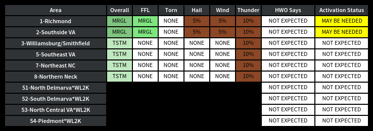
SKYWARN Activation Status Report
Here is the latest SKYWARN Activation Status Report from Wakefield SKYWARN. Click on the graphic below to access the discussion related to any featured weather threats.

How to Participate
You do not need to be a trained spotter to participate in SKYWARN nets. Please listen to what Net Control is asking for and ensure your reports meet the reporting criteria. Reports should be the result of your own first-person observations -- not what you saw on TV, got from a friend, or heard on the scanner. To make a complete report on the first try, remember the SKYWARN T-L-C report format:
- Time - When did the event occur? Now? 10 minutes ago? If you're not sure, "event time unknown" is acceptable.
- Location - Where did it happen? A street address, nearby cross-street, or distance from a recognizable landmark is significantly more helpful than GPS coordinates. NWS prefers "1 mile west of Coatesville in Hanover County" over "37.87836, -77.62652"
- Conditions - What are you observing? Be precise. Do not speculate. If you're not sure what you're looking at, don't report it until you have confidence in what you're seeing. And of course, if it doesn't meet reporting criteria, don't report it.
When you give a report involving any kind of measurement (such as hail size or snowfall depth) specify whether the values you are providing are actual measurements or an estimate. Do not attempt to estimate wind speeds -- instead, focus on the damage being caused by the wind. Hail sizes can be estimated relative to the size of common coins or other objects -- but please avoid "marble size" hail reports. Marbles come in different sizes, nickels don't.
The SKYWARN electronic log system tracks each spotter's report quality over time. Spotters with an abnormally high percentage of low-quality, inaccurate, sub-severe/non-reportable, or third-party reports may find that their future reports are ignored instead of being relayed to NWS.
If you are unable to reach a SKYWARN net, you may phone in your report to NWS Wakefield at 757-899-2415 or send it via e-mail.
Training Links
For the current SKYWARN Spotter training schedule, visit the NWS Wakefield SKYWARN page.
For amateur radio-related SKYWARN training (Net Control, Responder) visit the WX4AKQ web site.
Neighboring SKYWARN Programs
Ham radio communications for all counties and cities served by the National Weather Service Forecast Office in Wakefield are provided by the Wakefield SKYWARN Amateur Radio Support Team.
A few localities on the far western and northern fringes of the repeater are served by different NWS offices and thus different SKYWARN nets. Blacksburg SKYWARN (WX4RNK) and the NWS Blacksburg office serves a few localities on the far western fringe of the 88 repeater's coverage area, while several counties and cities to our north and west are served by National Capital Area SKYWARN (WX4LWX) and the NWS Sterling office.
If a SKYWARN net is active on our repeater, reports can be called in for any of the surrounding NWS offices. Your report will be electronically routed by Net Control to the appropriate office. However, hams may be best served by utilizing the appropriate local net for their area, when available.
